A passage to Brightlingsea
Heading for the East Coast
Leave Portsmouth for the West Country and the first question is usually what the tide is doing at the Needles. Turn the other way and it’s Selsey Bill that sets the clock. For a while you can still measure the day by familiar things ashore. Brighton’s breakwaters, the cliffs at Beachy Head and the ferries off Dover each tell you where you are. Beyond North Foreland the land gets lower. A buoy that looks as though it stands in the middle of nowhere can mark the edge of all the water you have.
If you’re sailing from the Solent to the East Coast for the first time, Brightlingsea makes a good destination. It’s just inside the River Colne, there’s a harbour team to call on the way in, and once ashore you can walk into town for supper. Getting there gives you a reason to unfold the Thames Estuary chart and make sense of all those banks and channels.
We sailed from the Solent to the East Coast three times aboard Ghostly Goose, though we never kept a detailed log of those trips. We did keep logs of our three summer cruises to Holland, which took us along the same stretch of the Sussex and Kent coast. In 2016 we stopped at Brighton and Dover before crossing to France. This guide draws on those logs as far as Dover, then follows the coast north towards Essex, using current harbour directions, surveys and East Coast pilotage. Area 15’s 2016 Holland cruising log
Leaving Portsmouth and rounding Selsey Bill
Start the tidal work at Selsey and work back to your berth. From Gosport you have the harbour entrance and the traffic off Spithead to deal with before you make much easting. From Cowes there is more of the eastern Solent to clear. Plot the banks and ledges between you and open water, then see what time that puts you off the Bill. The same breakfast departure can produce quite a different day from opposite ends of the Solent.
For boats under 20 metres, Portsmouth’s Small Boat Channel runs down the western side of the harbour entrance. Outbound boats pass close west of Ballast Pile. If you have an engine, use it between the pile and No 4 Bar buoy. Anyone leaving Gunwharf Quays or Town Camber must get permission on VHF 11 before crossing to the Small Boat Channel. Have a look at the harbour diagram before slipping lines, particularly if this is your first departure from the Portsmouth side. King’s Harbour Master’s direction and diagram
At Selsey, compare the Looe Channel with the longer passage outside the Owers. The inshore route saves miles if you have enough depth, can identify the marks and can hold your intended track. Going outside buys sea room. On the 2012 Holland trip, Goose reached the Looe around low water and carried a fair stream all the way to Dover. There’s a detail in the log that matters as much as the time of tide. The crew kept their speed up to make it work. If your boat loses a couple of knots in a head sea, work out where you’ll actually be when the stream turns. Portsmouth to Dover, June 2012
Brighton or Eastbourne for the night?
Brighton gives you a stopping place before Beachy Head. That makes it a useful decision point. If the crew have had a good day and the conditions suit, Eastbourne gets the headland behind you. If the visibility is closing in or the next watch is tired, Brighton puts supper and a night’s sleep within reach.
For Brighton, book ahead if you can and call the marina on VHF 80 or 37 for a berth and entrance advice. Approaching from the west, give the breakwater end room for boats coming out. In a swell, reflected waves off the wall can make the last few minutes the roughest part of the approach. Sand also moves into the entrance after storms. At the review date, Premier advised boats drawing more than one metre to keep at least two hours clear of low water either side. Check the latest notice for your visit, even if the marina has already confirmed your berth. Brighton Marina approach and notices
At Eastbourne, Sovereign Harbour lies beyond the town when coming from Beachy Head. Call on VHF 17 at the safe water mark. Have the entrance plan to hand before turning in. The approach passes a wreck, the sector light identifies the leading line, and parts of the outer harbour dry alongside the buoyed channel. Once through the breakwaters, follow the lock signals. Sovereign Harbour approach and locking information
On 20 June 2013, Goose spent about seven hours in thick fog between Portsmouth and Eastbourne. A replacement plotter had just brought the radar back into service. Comparing its returns with the AIS display on the iPad, the crew found several fishing boats and even some small ships that weren’t showing on AIS. They reached Sovereign Harbour at half past eight. Paul still had the batteries to see to, while Kath and Lucy went ashore for shopping and a takeaway. It’s an honest picture of what a long day costs, even in a calm sea. Allow for the hours someone has spent concentrating as well as the miles the boat has travelled. Portsmouth to Eastbourne, June 2013
Beachy Head and Dungeness
Treat the two headlands as separate decisions. Look at the stream and wind you expect off Beachy Head, then do it again for the time you’ll reach Dungeness. Allow for the wind over the preceding hours too. A sheltered berth can give a thoroughly misleading impression of the sea that’s still running offshore.
On Goose, heading east for Dover, we used to allow about another five miles beyond Beachy Head when working out our timing. We wanted to have covered those miles by the time the east-going stream ran out there, preferably with a little time in hand. At five knots that’s a whole hour’s sailing after you’ve rounded the headland. Get there late and you can spend the next couple of hours pushing tide, which makes a nonsense of a perfectly good-looking arrival time for Dover. When you do your own sums, follow the hourly tidal streams along your intended track past Eastbourne and see where your boat needs to be when the stream turns.
On Goose we generally cruised at about seven knots and could make eight at a push. At seven knots, with the tide timed well, we reckoned on about 14 hours from the Looe Channel to Dover. We could carry the fair tide most of the way, though it might turn against us with about an hour still to go. Allow separately for the run from your berth to the Looe.
If five knots is as much as your boat will do, I’d make two days of it. The stream on the approach to Dover can run at over two knots against you. At five knots through the water, that can leave you making less than three over the ground. If you still have ten miles to go, that’s more than three hours of sailing at the end of an already long day.
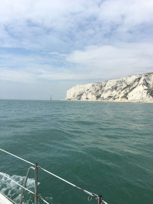
Beachy Head from Ghostly Goose on the homeward passage, August 2016.
Brighton breaks the trip before Beachy Head. Eastbourne gets you round the headland on the first day and lets you time the next morning’s departure from Sovereign Harbour for the run past Dungeness to Dover.
The 2016 log gives both sides of it. Eastbound from Brighton, Goose averaged 9.6 knots over the ground while making 7.7 through the water. By that measure it was an excellent passage. From the cockpit the crew scarcely saw Dungeness, and Dover’s entrance only appeared through the fog from about 200 metres away. Coming home in August, they left Dover at first light in almost flat water. Near Dungeness a headwind built, and for three hours the boat slammed into short, steep seas. That’s a fair argument for leaving some slack in the day, whichever way you’re going. The outward passage · The return from Dover
Along the coast towards Folkestone, check the Lydd and Hythe range programmes against the charted danger areas. Allow room for any detour and heed range safety instructions. If you’ve slowed for fog or stood farther offshore to clear a range, update your arrival time while you still have a choice about the next leg. Ministry of Defence firing times

Approaching Dover from Brighton, July 2016.
Calling in at Dover
Make the first call to Dover VTS on VHF 74 when two miles off. Give your position, intentions, boat dimensions and any defect affecting manoeuvrability. The port asks for a second call at 200 metres for permission to enter. If you cannot establish contact, keep well clear of both entrances. Tell VTS if you cannot use your engine. A ferry can be hidden behind the harbour wall while everyone in the cockpit has a splendid view of an apparently empty gap.
Read the port’s arrival procedure in advance so the crew know which entrance and signals to look for, and where they’re going once inside. VHF 80 is for the marina berth. Keep a listening watch on 74 for port movements. On the way from the Solent to the East Coast, Dover is a handy place to break the journey. With the boat tied up, you can look at the next day’s tide and decide whether to carry on to Essex or spend a night in Ramsgate first. Dover Marina arrival procedure
Past Deal to Ramsgate and North Foreland
Leaving Dover, keep an eye on ferries crossing your track as well as ships running along the Strait. A coastal passage towards Deal needn’t take you across the main traffic lanes. Mark the limits of the traffic separation scheme on your chart. Sailing vessels and boats under 20 metres may use the inshore traffic zone. If you do have to cross a traffic lane, Rule 10 calls for a heading as nearly as practicable at right angles to the traffic flow. In a strong stream your track over the ground can look quite different. Maritime and Coastguard Agency guidance for the Dover Strait
Off Deal the Goodwin Sands lie between the coast and open water. Zoom in far enough to see the lesser banks on the Ramsgate approaches. Watch the way the stream sets across your course, especially when a mark seems slow to come abeam. Ramsgate’s harbour authority describes alternatives from the south and advises against its close inshore route at night.
At Ramsgate the recommended yacht track runs south of the commercial approach channel. Call Port Control on VHF 14 for permission to enter or leave. The stream sets across the entrance, so have the holding area and your approach clear before closing the breakwaters. A night here can buy something more useful than another few miles north, a fresh crew and a full stretch of daylight for the estuary. Ramsgate Harbour approach
Crossing the Thames Estuary
Spread the chart out far enough to see Kent and Essex together. From North Foreland, the straight line towards the Colne runs across the grain of the estuary. The deep channels tend to follow the banks, while you want to get from one side of them to the other. Start by identifying where your boat can cross each bank. Join those places up afterwards. It soon becomes clearer which shipping channels you need to cross and where a missed tide would leave you.
Choosing a route for your draught
Compare a passage farther out with one through the banks. Going round the end of a bank can remove a shallow crossing, at the cost of more time offshore. On the shorter route, the whole day may depend on a single swatchway, a gap through the sand, having enough water when you get there. Look at the date of its last survey. East Coast Pilot points to local survey work on the Sunk swatchways and on Foulger’s Gat through the London Array. An old plotter track can be beautifully precise about where the water used to be. East Coast Pilot chartlets and survey resources
Work out the depth at the shallowest part for your expected arrival there. Add the predicted tide height to a charted sounding, or subtract the drying height from the tide height, then allow for draught, sea state and clearance beneath the keel. Run it again for a late arrival. On a rising tide, losing an hour might give you more water at the bank but less fair stream beyond it. On a falling tide, the same delay could close the route. Decide while planning where you’ll have enough room and depth to turn away.
Princes Channel, Fisherman’s Gat and the Black Deep
Princes Channel carries shipping along the southern estuary. Fisherman’s Gat is another commercial approach, leading between the banks towards the Black Deep. Trace them on the PLA’s routeing guide and you’ll see why a ship that appears to be passing clear may turn towards your intended crossing. Look along the fairway in both directions and identify its far edge. A deep draught ship has little choice about where it goes, even when there appears to be open water for miles on either side. PLA passage planning and routeing guide
A pleasure vessel may cross the Black Deep. Under PLA General Direction 17.5, a vessel drawing less than 6 metres needs London VTS permission to use the Black Deep Channel as a route along it. The direction expressly excepts pleasure vessels crossing it. Look at what your planned track actually does. If you need to turn and run along the Black Deep to clear the next bank, choose another route or obtain permission. When crossing, you must still avoid impeding shipping confined to the fairway and follow any VTS instruction. PLA General Directions, section 17.5
Plot the wind farms and check current works and safety zones. A line of turbines makes a fine landmark in clear weather, but says little about the water between you and the next row. Consider what you would do if the visibility closed down before a swatchway, with a ship approaching the crossing beyond it. If the answer depends on finding a small mark at just the right moment, Ramsgate is a good place to wait for a better day.
Finding the Colne and entering Brightlingsea
Mersea Island helps make sense of the Essex shore. The Blackwater opens to its south and west, while the Colne leads up its eastern side. Pick out the channels on the chart before trying to recognise either river from the cockpit. With land this low, a building may be visible long before you can see the shape of the shore beneath it. Follow the marked water and compare the soundings with what you expected before turning towards the creek.
Brightlingsea lies just inside the Colne. Bateman’s Tower is a useful landmark, and the harbour publishes separate May 2026 surveys of the entrance and main channel. Look at both. The leading marks into the creek are known locally as the Cricket Stumps. The tide gauge on the green beacon indicates the least depth on their line. Once inside, there’s a second depth to consider, the water your boat will have at her berth at the next low tide. Brightlingsea navigation advice and May 2026 surveys
Call Brightlingsea Harbour on VHF 68 on approach. Give your draught and ask where to berth. On the visitor pontoons in the creek, you’ll have the passing boats for company and go ashore by tender or water taxi. If someone aboard needs to walk ashore, speak to Waterside Marina before setting out. Its entrance has a sill which the harbour lists as drying one metre above chart datum. Check both the berth and the time you can get over the sill. Visiting Brightlingsea by boat
The water taxi also works on VHF 68. Check the last run before ordering supper at the Yachtsman’s Arms. There are showers and laundry facilities ashore, a bakery and independent shops for provisions, and a maritime museum if you have a morning to spare. A walk out towards Bateman’s Tower lets you look back at the entrance you’ve just come through. For a November 2026 visit, ask where to land. The harbour announced a shorter temporary hammerhead at the Town Jetty during winter work expected to last about six weeks from early November. Water taxi timetable · Harbour notices · Facilities ashore
Planning your stops from the Solent to the East Coast
For a first trip, try planning the Kent to Essex day first. Work back from daylight at Brightlingsea, the water you need over the banks and the stream off North Foreland. That should tell you whether the previous night is better spent in Ramsgate or Dover. Then see what sort of day that leaves from Eastbourne or Brighton. A spare day on the way out gives you the option of waiting for visibility while you still have somewhere comfortable to do it.
- Run the plan at your usual cruising speed and again at the speed the boat makes in a short head sea. Compare the depth and daylight left at the far end.
- For each longer leg, choose an alternative harbour and mark the point at which you’d need to turn for it. Check its entrance as carefully as the one you hope to use.
- Give someone else aboard the harbour calls, tide notes and next expected depth. It makes for an easier arrival if the person who knows the plan can hand over the helm or go forward with the fenders.
Brightlingsea is a good place to call this passage complete. The Blackwater is within reach, and farther up the coast there are the Orwell, Stour and Deben. Give those rivers a cruise of their own. For today, there’s the last water taxi to catch.
Passage information reviewed on 13 November 2026. Use current corrected charts, tide tables, forecasts, harbour directions and Notices to Mariners for navigation. The Area 15 logs describe conditions on the dates of the voyages.
Have you sailed from the Solent to the East Coast recently? We’d welcome a comment about the route you chose, the tide you found, a berth that worked well or something here that needs correcting. Please say when you visited. A harbour notice or survey link helps us check an update, and we’ll gladly credit useful contributions in future revisions. For a longer passage account or photographs from your trip, share your experiences with Area 15.